Subsurface Utility Engineering
Engineering projects depend on accurate, reliable information to support design, constructability, and risk management. However, underground utilities—often undocumented, incomplete, or inaccurate—represent one of the greatest sources of uncertainty in project development.
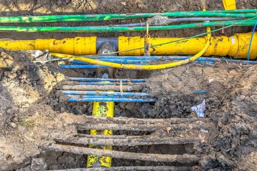
Subsurface Utility Engineering (SUE) provides a structured engineering approach to identifying, analyzing, and documenting existing underground and above-ground utilities, enabling more informed, defensible decisions across planning, design, and construction.
What We Do
Kiwa, through T2 Utility Engineers, delivers professional Subsurface Utility Engineering (SUE) services using industry standards and advanced technologies to improve utility data quality and reduce project risk.
We support engineering teams, designers, and project owners with:
- Utility investigation and data collection – Records research, field reconnaissance, geophysical designation (GPR, EM), and vacuum excavation to locate and verify utilities
- Utility mapping and documentation – Accurate depiction of underground infrastructure with CAD, GIS, and BIM-ready deliverables
- Engineering analysis and risk assessment – Professional interpretation of utility data to support design and decision-making
- Utility conflict identification and mitigation – Early identification of potential conflicts to improve constructability and avoid redesign
- Standards-based delivery (ASCE 38) – Application of defined quality levels to ensure consistent, reliable, and defensible utility information
- Integrated project support – Coordination with design teams, contractors, and stakeholders to manage utility impacts throughout project development
Why Subsurface Utility Engineering Matters
Incomplete or inaccurate utility information is a leading cause of design conflicts, construction delays, safety incidents, and costly change orders.
Subsurface Utility Engineering helps address these risks by providing reliable utility data early in the project lifecycle. Our expertise helps:
- Reduce utility-related risk and uncertainty by replacing unreliable records with verified data
- Improve project design and constructability through accurate understanding of subsurface conditions
- Prevent costly redesigns and delays caused by unexpected utility conflicts
- Enhance safety by reducing the risk of utility strikes during excavation
- Support defensible engineering decisions using standardized, quality-level data
How Kiwa Delivers Value
Kiwa combines professional engineering judgment, advanced technologies, and established standards to deliver high-quality utility data and insight.
Our services help clients:
- Mitigate utility risk, improve safety
- Improve early-stage decision-making with reliable, field-verified utility data
- Reduce construction impacts by identifying and resolving conflicts before work begins
- Increase cost and schedule certainty by minimizing change orders and delays
- Strengthen coordination between project teams, utility owners, and stakeholders
- Deliver accurate, project-ready information to support design, construction, and long-term asset management
Our Services
- Subsurface Utility Engineering (SUE) ASCE 38 investigations
- Utility investigations
- Utility mapping, designation, and locating
- Vacuum excavation and Quality Level A verification
- Surveying and mapping / ASCE 75 geospatial services
- Utility coordination and conflict mitigation
- Advanced geophysics
- Utility risk management for damage prevention
Who We Serve
Engineering firms and design consultants
Public agencies and infrastructure owners
Developers
General Contractors
Transportation, utility, and municipal project stakeholders
Our services include
Kiwa T2 uses high-resolution geophysical survey technologies to help investigators identify subsurface anomalies and potential forensic evidence while efficiently narrowing large search areas for follow-up investigation.
Subsurface Utility Engineering (SUE) Investigations (ASCE 38)
Professional investigation and analysis of above-ground and underground utilities to provide reliable utility information following the ASCE 38 that supports safer, more informed project planning and design.

Urban Geophysics
Identify hidden subsurface features and anomalies with advanced geophysical investigations that help reduce uncertainty, manage risk, and support informed project decisions.
Cemetery/Unmarked Internment Mapping
Kiwa T2 provides non-invasive geophysical investigations to identify and map potential burial-related subsurface anomalies, helping cemetery owners and organizations make informed decisions with care, respect, and confidence.
Inflow and Infiltration Investigations
Identify and confirm the location of groundwater entering sewer systems with inflow and infiltration investigations that support data-driven rehabilitation and asset management decisions.
Cross-bore Prevention and Verification
Protect critical underground infrastructure and reduce HDD-related risk with CCTV-based cross-bore prevention and verification services from Kiwa T2.
3D Models and Digital Twins
Transform complex utility and infrastructure data into accurate, defensible 3D models that support better planning, design coordination, risk management, and decision-making.
Tree Root Mapping
Advanced geophysics helps identify and map shallow tree root systems, supporting informed tree management decisions and reducing conflicts with planned construction or existing infrastructure.
Dye Testing
Kiwa T2 provides Dye Testing services to verify sewer connectivity, helping property owners, developers, and engineers identify where private sewer connections discharge into municipal infrastructure.
Archaeological Investigation Support
Kiwa T2 helps identify, map, and document buried archaeological features and cultural heritage resources using advanced geophysical technologies and precise survey methods.
Materials Engineering Services for Construction Quality
Comprehensive materials engineering solutions, including mix designs, failure analysis, and quality management, supporting contract compliance and project quality.

Quality Assurance and Quality Control for Alternate Delivery Method Projects
Comprehensive QA/QC solutions for major transportation projects using alternate delivery methods, ensuring quality and schedule compliance.

Chamber and Maintenance Hole Modelling
Accurate 3D chamber and maintenance hole modelling that provides detailed, survey-grade information for design, planning, asset management, and utility coordination projects.

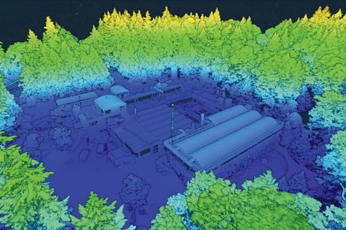
LiDAR and Mobile Mapping
Capture accurate, detailed, and comprehensive spatial data with LiDAR and mobile mapping solutions that support planning, design, construction, asset management, and infrastructure decision-making.

Geographic Information System (GIS)
Accurate GIS mapping and asset data management solutions that help municipalities, campuses, and industrial organizations better understand, manage, and plan underground infrastructure.
Overhead/ Aerial Asset Inventories
Accurate mapping and documentation of overhead utility infrastructure to support planning, design, utility coordination, and long-term asset management.
Utility Mapping (ASCE 38 not requested)
Accurate utility data tailored to your project needs, helping you understand existing infrastructure and manage risk without the scope of a full SUE investigation.
Public Locate Project Management
Comprehensive management of public utility locate projects, ensuring safe excavation, regulatory compliance, and efficient project delivery.
Marker Ball Installations
Simplify future utility locating and verification by installing marker balls on difficult-to-detect underground infrastructure.
Utility Coordination
Utility impacts and relocations present significant risks to infrastructure project delays. T2 Utility Engineers Utility Coordination professionals develop a managed approach to identify and guide the complex utility conflict resolution process, working c...

FAQs about Subsurface Utility Engineering
Does Kiwa support complex urban environments?
Yes.